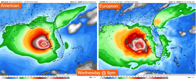
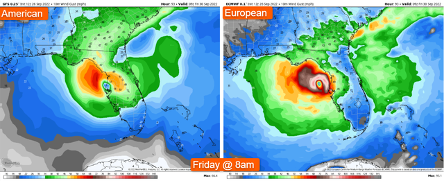
Significant update: If you are in or around Tampa Bay and points up the coast, I would strongly suggest you pack and leave. This is not a normal "we're Florida, we can handle this" situation. Both forecast models have come into significant agreement with the afternoon update (12z). Both have the eye pulling up nearly parallel to the Bay at 8pm Wednesday, then stalling and not exiting until 8am Friday. If the models are wrong in the easterly direction, then the eye remains 50 miles farther west and the storm brings hurricane force winds, flooding rain and storm surge into the Bay. If the eye is 50 miles farther east, however, Tampa Bay will sit within the eastern eye wall of this storm for 24-36 hours as it decays. The National Weather Service routinely issues tornado warnings at the location of landfall due to a strong likelihood of tornadoes and sustained wind. If the eye wall sits over the City of Tampa Bay, I am highly concerned for people's lives who elect to remain there. This is a Harvey type possibility. I prefer to stay out of the business of telling people what they should do, and just tell potential impacts. This scenario is different. I recall listening to a broadcast meteorologist in Houston at a conference who was talking about how he was trying to figure out how to tell people to get on their roof due to the flooding because they needed to be rescued, but then he realized tornadoes were inbound. What do you tell your viewers in that scenario? Portions of Tampa Bay will experience this if the models verify like they are indicating as of now. Again, it can change, but these are not things you want to decide within 12-24 hours of the landfall when many others are doing the same.
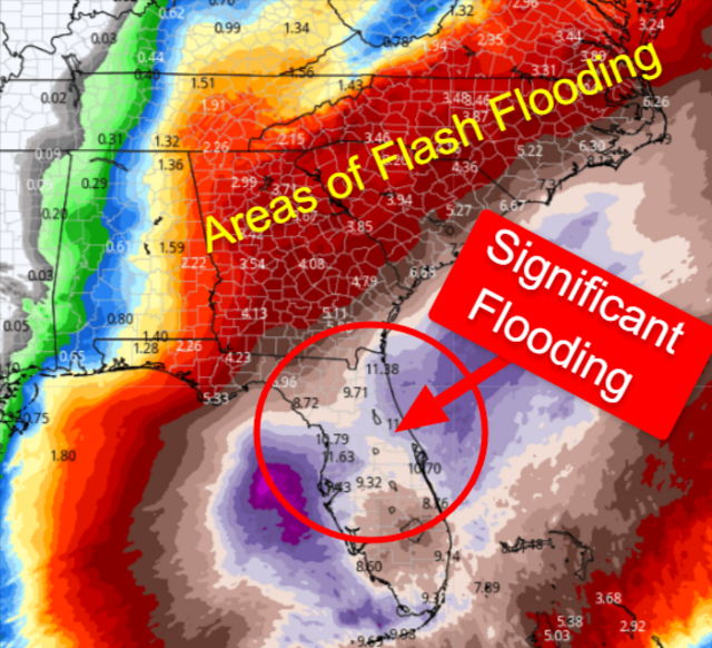
As of 1pm Monday, Hurricane Ian is beginning rapid intensification in the northwestern Caribbean as it turns to the north. It will pass over western Cuba, and then make an approach to the Gulf coast of Florida. The trough in the northern U.S. is now expected to lift (accurately predicted by @FishwaterDawg last week), and a Category 3 Ian will lose forward motion as steering patterns begin to compete. These are the ingredients of a very dangerous situation across western Florida, including Tampa. If you live along the coast, be sure to pay attention to local authorities and simply follow their guidance. No need to panic; just prepare.

There will also be a threat for tornados within Ian's outer rain bands beginning as early as Tuesday. Tornadoes in tropical systems often occur with little to no advance warning, but are typically weak. With that, a few tornadoes could be on the stronger side, but it is rare to see many. The most likely region for tornadoes is within the northeast quadrant of a landfalling tropical system.
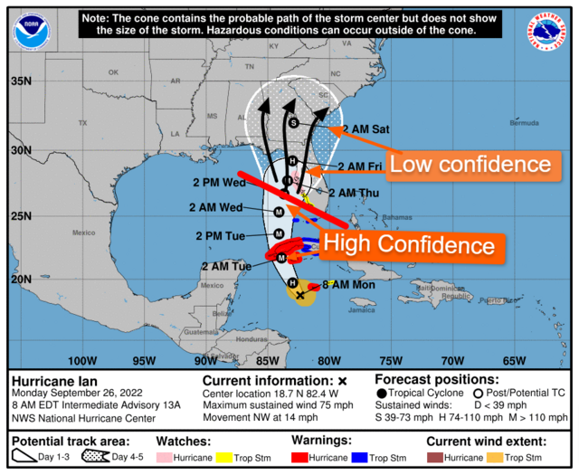
The forecast track over the next 3 days is high confidence. As is the intensity. However, the track beyond day 3 is very subject to change. The center of circulation could literally be anywhere within the cone of uncertainty, with impacts much larger than the cone itself.
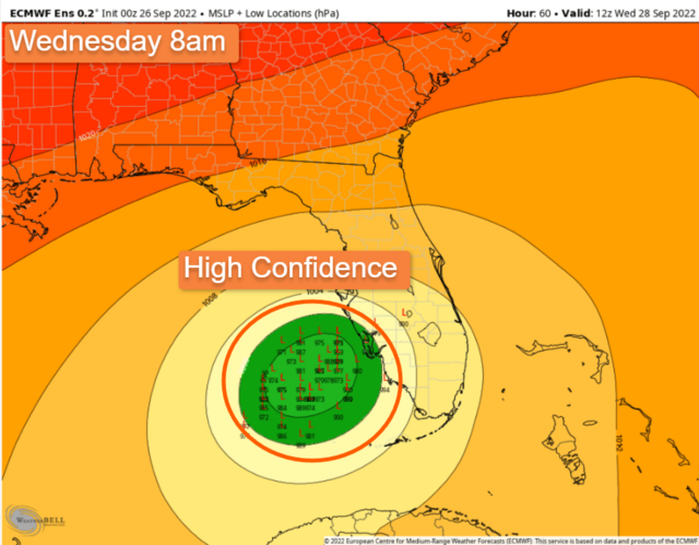
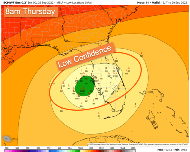
In the two pictures below, the first one shows the Ensemble members off the European forecast model. Each "L" is a potential location for the center of circulation depending on many variables within the modeling data. This output depicts high confidence. However, that changes in a major way from Wednesday morning to Thursday morning. Minor errors in the upper level forecast could allow the track to shift greatly from Wednesday to Thursday. In the second image, the spread is much larger on all forecast models, and confidence drastically decreases. That error continues beyond. Going back to the original NHC forecast track above, the center again may be anywhere within the cone of uncertainty.
It is important to follow directions from the local NWS offices (weather.gov). The National Hurricane Center is the best place to get your most accurate, up-to-date info on the storm and its track. If you are on the northeastern quadrant of this system, you are at greatest risk to receive the highest impacts from this storm. That continues inland too. Florida residents (especially central FL) should be finalizing preparations now. Dangerous storm surge along the coast, inland flooding, and hurricane force winds can be expected in certain locations. Power outages are likely across a large swath of Central Florida. Georgians south of a line from Columbus to Macon to Savannah should continue to monitor, but I would expect inland tropical storm watches / warnings in the coming days. As of now, your greatest threat is from inland flooding, especially flood prone areas, and isolated tornadoes. Tropical storm force winds are possible. Your local NWS office has the best, most accurate info for your location. The Carolinas should continue to monitor. There are about 10% of outcomes which bring Ian over Florida, into the Atlantic, then turn it north back into the Carolinas with a second landfall at the end of the week. It is something to monitor. Alabama is mostly clear of this, but keep an eye on updates from the NHC.
If you have any questions, I can answer a few for the next 30 minutes or so. Your best, most reliable and accurate info, can be found at your local NWS Office.


As of 1pm Monday, Hurricane Ian is beginning rapid intensification in the northwestern Caribbean as it turns to the north. It will pass over western Cuba, and then make an approach to the Gulf coast of Florida. The trough in the northern U.S. is now expected to lift (accurately predicted by @FishwaterDawg last week), and a Category 3 Ian will lose forward motion as steering patterns begin to compete. These are the ingredients of a very dangerous situation across western Florida, including Tampa. If you live along the coast, be sure to pay attention to local authorities and simply follow their guidance. No need to panic; just prepare.


There will also be a threat for tornados within Ian's outer rain bands beginning as early as Tuesday. Tornadoes in tropical systems often occur with little to no advance warning, but are typically weak. With that, a few tornadoes could be on the stronger side, but it is rare to see many. The most likely region for tornadoes is within the northeast quadrant of a landfalling tropical system.

The forecast track over the next 3 days is high confidence. As is the intensity. However, the track beyond day 3 is very subject to change. The center of circulation could literally be anywhere within the cone of uncertainty, with impacts much larger than the cone itself.
In the two pictures below, the first one shows the Ensemble members off the European forecast model. Each "L" is a potential location for the center of circulation depending on many variables within the modeling data. This output depicts high confidence. However, that changes in a major way from Wednesday morning to Thursday morning. Minor errors in the upper level forecast could allow the track to shift greatly from Wednesday to Thursday. In the second image, the spread is much larger on all forecast models, and confidence drastically decreases. That error continues beyond. Going back to the original NHC forecast track above, the center again may be anywhere within the cone of uncertainty.


It is important to follow directions from the local NWS offices (weather.gov). The National Hurricane Center is the best place to get your most accurate, up-to-date info on the storm and its track. If you are on the northeastern quadrant of this system, you are at greatest risk to receive the highest impacts from this storm. That continues inland too. Florida residents (especially central FL) should be finalizing preparations now. Dangerous storm surge along the coast, inland flooding, and hurricane force winds can be expected in certain locations. Power outages are likely across a large swath of Central Florida. Georgians south of a line from Columbus to Macon to Savannah should continue to monitor, but I would expect inland tropical storm watches / warnings in the coming days. As of now, your greatest threat is from inland flooding, especially flood prone areas, and isolated tornadoes. Tropical storm force winds are possible. Your local NWS office has the best, most accurate info for your location. The Carolinas should continue to monitor. There are about 10% of outcomes which bring Ian over Florida, into the Atlantic, then turn it north back into the Carolinas with a second landfall at the end of the week. It is something to monitor. Alabama is mostly clear of this, but keep an eye on updates from the NHC.
If you have any questions, I can answer a few for the next 30 minutes or so. Your best, most reliable and accurate info, can be found at your local NWS Office.

